Why Your Geospatial Data Search is Taking Too Long and How to Fix It
 Parker Dinkins
If you've ever tried to find geospatial data, you know the struggle. You spend hours, sometimes days, bouncing between different geoportals and databases, trying to piece together the datasets you need. Each platform has its quirks, search functions that don’t quite align, and data that's sometimes out-of-date or hard to access. The frustration is real, and it's something we've all experienced.
I’ve been there staring at multiple tabs, comparing datasets, and wondering why there isn’t an easier way to find what I need, and quickly preview it without opening more tabs or third party software. It’s a challenge that geospatial professionals face daily. But what if there was a way to bring all those datasets together in one place, cutting down on the time and effort spent chasing data across the internet?
The Struggle of Data Fragmentation
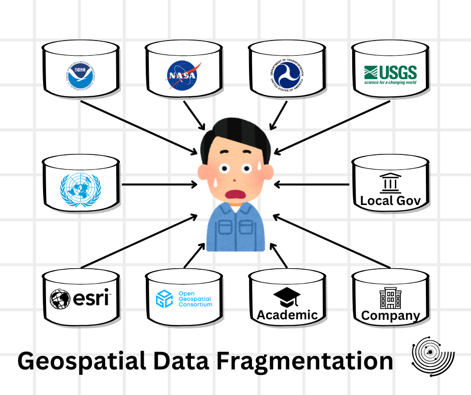
Let’s face it, geospatial data is incredibly fragmented. Whether you're working on a school project, urban planning, environmental studies, or disaster management, you’re likely dealing with data scattered across government websites, academic institutions, and private databases. Each of these sources has its own interface, its own way of structuring data, and its own challenges when it comes to accessing what you need.
This fragmentation isn’t just an inconvenience, it’s a time sink. It slows down projects, increases the likelihood of missing important datasets, and creates a lot of frustration. You might find yourself thinking, "Why can’t this be easier?"
Enter GISDATA.io Galileo
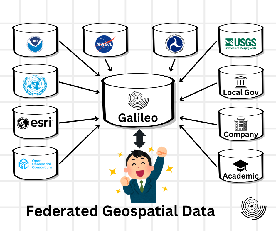
That’s where GISDATA.io Galileo comes in. It wasn’t built just to be another tool in the toolbox but as a response to the very real problem of fragmented geospatial data. Galileo is designed to be a federated geospatial data search engine, pulling together datasets from over 1000’s sources into a single, unified search experience with built in previews and data management tools.
Why GISDATA.io Galileo Matters
Galileo was built with these frustrations in mind. It’s not just about bringing data together, it’s about making your life easier. By federating searches across multiple sources, Galileo eliminates the need to jump from site to site, offering a single point of access to a massive range of geospatial data.
Think of it as a bridge to connect all those disparate data sources and make them accessible through one simple search. And it’s not just about convenience, it’s about empowering you to do your job more efficiently, with the confidence that you’re getting the most comprehensive and up-to-date data available.
A Tool Built for You
It’s about making data access straightforward so you can focus on what you do best, analyzing and applying that data to solve real world problems.
At its core, Galileo is about solving the problems we face as geospatial professionals. It’s about taking the time-consuming, frustrating parts of our jobs and making them easier. We all know the value of our time, and Galileo is designed to give some of that time back to you.
By centralizing the search process, Galileo frees you from the endless tabs and countless searches that often define our workdays. It’s about making data access straightforward so you can focus on what you do best, analyzing and applying that data to solve real world problems.
Conclusion
We all know the challenges of working with geospatial data. The hours spent searching, the frustration of navigating multiple platforms, and the constant concern about data accuracy are part of our daily grind. But it doesn’t have to be this way.
GISDATA.io Galileo isn’t just another tool, it’s a solution born out of the same frustrations you face. It’s about simplifying your workflow, making data more accessible, and giving you the confidence that you’re working with the best information available. Take a moment to explore what Galileo can do for you. It might just be the bridge you’ve been looking for.